WeatherAlert – Severe Storm Activity Intensifies Across Uttar Pradesh Districts
WeatherAlert – Large parts of Uttar Pradesh remain under thick cloud cover as unstable weather conditions continue to affect daily life, with no immediate improvement expected. The situation has been driven by an active western disturbance combined with localized pressure systems, resulting in widespread atmospheric instability across the state.
Heavy Rainfall Expected in Eastern and Terai Regions
The eastern districts and Terai belt are likely to experience the most intense impact. According to the India Meteorological Department (IMD) in Lucknow, several districts may witness heavy rainfall accompanied by lightning and strong winds. These conditions are expected to disrupt routine activities and could pose safety risks for residents.
Areas such as Azamgarh, Mau, Ballia, Deoria, Gorakhpur, Sant Kabir Nagar, Basti, Kushinagar, Maharajganj, Siddharth Nagar, Gonda, Balrampur, Shravasti, and Ambedkar Nagar are forecast to receive significant rainfall. Rapid cloud movement, thunder, and frequent lightning are also expected across these regions, particularly in Purvanchal and adjoining Terai areas.
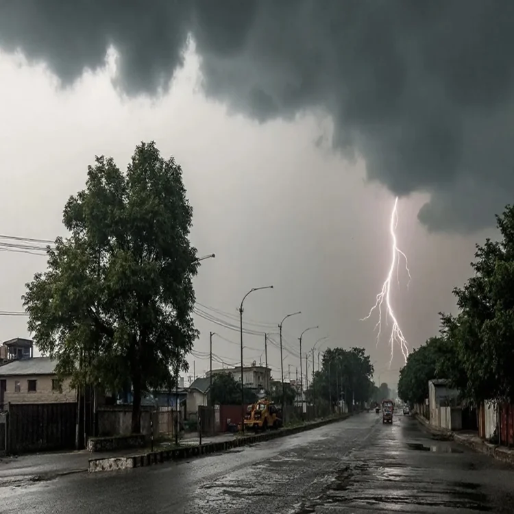
Red Alert Issued for Severe Thunderstorms
Earlier warnings from the IMD placed several districts under a red alert, indicating the likelihood of severe weather events. Regions including Rae Bareli, Amethi, Sultanpur, Ambedkar Nagar, Ayodhya, Basti, Unnao, Lucknow, Barabanki, and Gonda may experience intense thunderstorms along with hail and strong winds reaching speeds of 50 to 60 kilometers per hour.
Such conditions could lead to power outages, damage to standing crops, and potential risks to temporary structures. Authorities have emphasized preparedness as these weather systems remain highly active.
Orange Alert Covers Wider Areas
In addition to the red alert zones, a broader set of districts has been placed under an orange alert. These include Mirzapur, Prayagraj, Sant Ravidas Nagar (Bhadohi), Varanasi, Jaunpur, Pratapgarh, Azamgarh, Sant Kabir Nagar, Hardoi, Sitapur, Bahraich, Siddharth Nagar, Balrampur, Shravasti, Shahjahanpur, Lakhimpur Kheri, and Pilibhit.
These areas are expected to receive moderate rainfall along with thunderstorms, lightning, and gusty winds ranging between 40 and 60 kilometers per hour. While the intensity may be slightly lower than red alert regions, the conditions are still considered potentially disruptive.
Temperature Variations Across the State
The ongoing weather activity has also led to uneven temperature patterns across Uttar Pradesh. Central and eastern districts, including Lucknow, have recorded a marginal rise in temperatures by around 1 to 2 degrees Celsius. In contrast, north-western parts of the state have seen a noticeable drop of up to 5 degrees Celsius due to persistent rainfall and strong winds.
These fluctuations reflect the broader impact of the active weather systems influencing different parts of the state in varying ways.
Administration on Alert, Residents Advised Caution
Local authorities in affected districts have been directed to remain prepared for emergency situations, particularly those related to lightning strikes and infrastructure damage. Disaster response teams are on standby as a precautionary measure.
Residents have been advised to stay indoors during thunderstorms, avoid open spaces, and follow official weather updates. Officials have also stressed the importance of adhering to safety guidelines until conditions stabilize.
With the current weather system still active, authorities continue to monitor developments closely to minimize risks and ensure public safety.