Myanmar : is hit by a magnitude 4.4 earthquake
Myanmar: Myanmar had an earthquake on Thursday with a magnitude of 4.4, according to a statement from the National Center for Seismology (NCS).
The earthquake happened 100 kilometers below the surface.
The NCS said in an X post, “EQ of M: 4.4, On: 18/12/2025 06:04:36 IST, Lat: 26.07 N, Long: 97.00 E, Depth: 100 Km, Location: Myanmar.”
According to the NCS, Myanmar had an earthquake of magnitude 3.8 earlier on December 11.
An earthquake of a magnitude of 4.6 hit the area on December 10 at a depth of 138 kilometers.
Myanmar’s extensive coastline makes it susceptible to tsunamis and earthquakes of both moderate and big size. The Indian, Eurasian, Sunda, and Burmese plates are the four tectonic plates that Myanmar is sandwiched between, and their interactions result in dynamic geological processes.
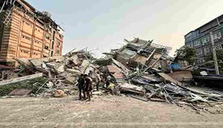
The World Health Organization (WHO) issued a warning about a number of rapidly increasing health risks for tens of thousands of displaced people in earthquake-affected areas following the magnitude 7.7 and 6.4 earthquakes that struck central Myanmar on March 28. These risks include HIV, water-borne and vector-borne diseases, and tuberculosis (TB).
The Andaman spreading center and the Sagaing Fault, a collision zone in the north, are connected by a 1,400-kilometer transform fault that passes through Myanmar.
Sagaing, Mandalay, Bago, and Yangon—which together account for 46% of Myanmar’s population—are all at higher earthquake risk due to the Sagaing Fault. Despite being somewhat far from the fault track, Yangon’s high population makes it very vulnerable. For example, Yangon was also hit by a powerful 7.0-magnitude earthquake that happened in Bago in 1903.